Spectacular cliff top views, and a walk with an abundance of historical sites of interest
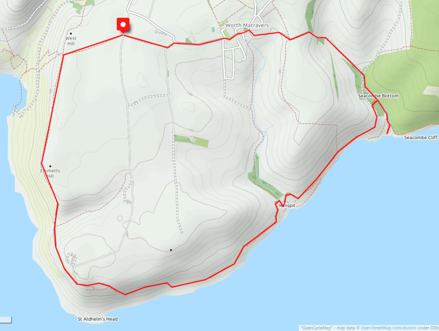
Duration: 2 hrs 45 mins
Distance: 8.9 kms (5.5 miles)
Total Ascent: 260m
Difficulty: Moderate
The picturesque village of Worth Matravers is the base for a number of great walks covering the section of coast from Chapman’s Pool around St. Aldhelm’s Head to Seacombe. It is also home to the timeless Square & Compass pub where you can enjoy a pint and a pasty looking down towards Winspit and the sea. This particular walk is one of our favourites and covers many of the historical points of interest found this area.
From Swanage take the A351 to Corfe and on the outskirts of the town take the left hand fork B3069 to Langton Matravers and Kingston. After the sign to Acton take the next left turn to Worth Matravers. There are two large car parks in the vicinity, one just up from the Square & Compass and the second located on the far side of the village, past the church and houses, past Weston Farm and finally up the gravel track after passing Renscombe Farm. Both car parks have an honesty box for a modest car park fee. For the purpose of this walk we will start in the latter Renscombe Farm car park (marked on the above map).
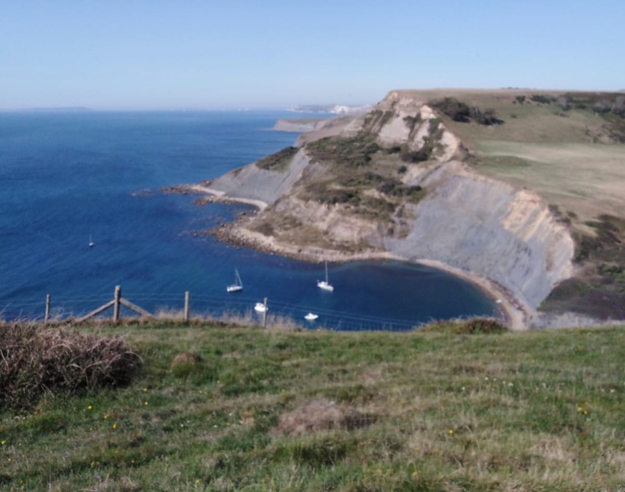
By the car park exit take the footpath across the field, heading in a westerly direction towards the coast. Cross the stile and you are now on the South West Coast Path. Turn left and you will have Chapman’s Pool at the foot of the cliffs and Weymouth Bay in the distance. After a short distance, nestled up against the stone wall and with a spectacular view of the Dorset coast, you will come across the Royal Marines Association Memorial which commemorates the men of the Royal Marines killed since 1945. After passing the memorial you will soon see the daunting site of a long set of stone steps leading up from a steep-sided valley, which you access having descended a similar set first! A stone bench is a welcome respite once have reached the top and have finished climbing out of the valley.
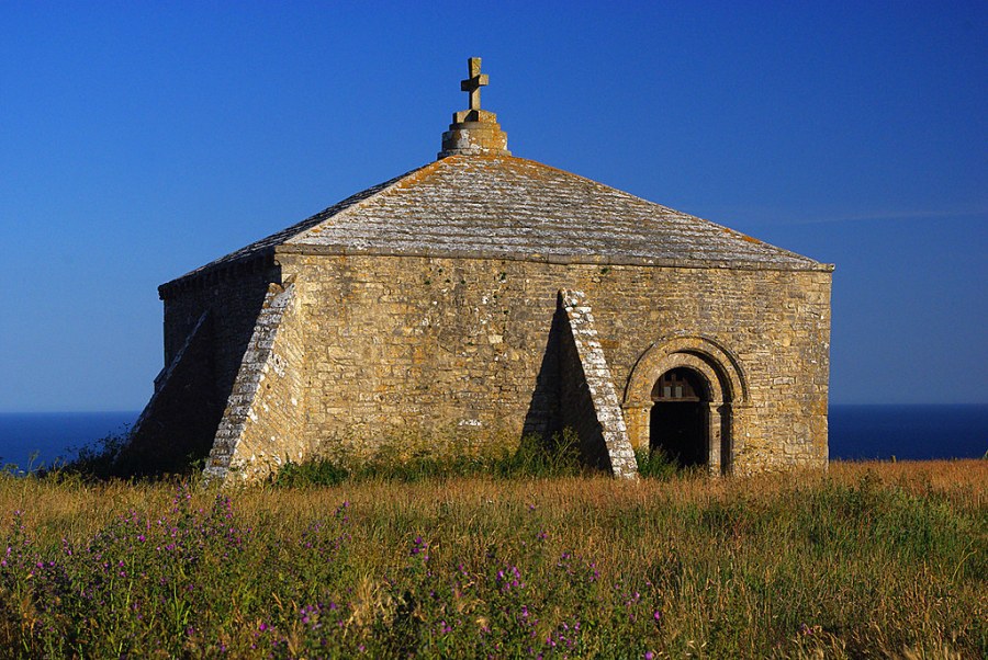
You will now be able to see terraced cottages plus the NCI volunteer coast watch station on the headland, and in between the 12th Century St. Aldhelm’s Chapel, which is worth a look inside – the stone pillars have names carved into them dating back to at least the 1600’s. Just past the Coastwatch station is the stainless steel Purbeck Radar Memorial which commemorates the pioneering radar work carried out at Worth Matravers during the 1940’s and the second world war. You can also see the footings of a radar tower in the vicinity. Just off the footpath here you can find a set of steep stone steps that can be navigated with care down to flat area on the cliff that contains the ruins of some of the old wartime buildings. If you take this route you can exit the site by walking eastwards and you will shortly rejoin the coastal footpath.
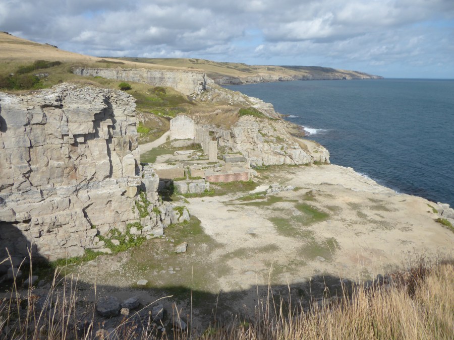
As you approach the valley of Winspit you will see carved into the side of the hills an extensive set of well preserved terraces known as Strip Lynchets which were created for medieval agriculture and cultivation. As you reach the valley you will notice below the remains some buildings, part of the now disused Winspit Quarry. This is one of the most noticeable of more than 200 18th Century quarries that were once in this area and where stone was shipped to London for buildings etc. [Note that to shorten the route, an option is to walk up the Winspit valley and along the footpath that will bring you up to Worth Matravers village.]
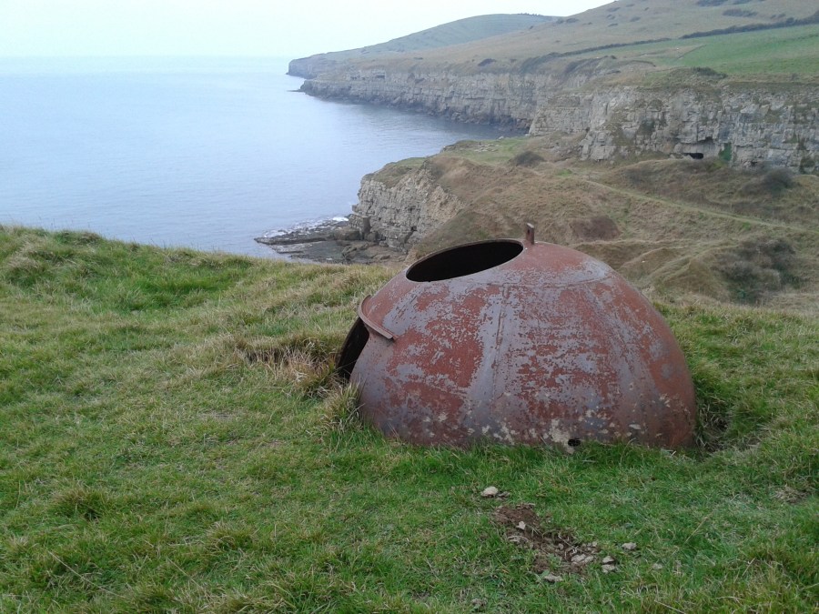
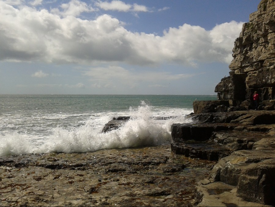
Continuing on the South West Coast Path you will pass further examples of quarrying and then you will arrive at the next valley known as Seacombe. As you approach Seacombe an Allan-Williams WWII turret (photograph left) can be seen on the far side of the valley, designed for one man and a machine gun to protect the bay. After descending the steps, instead of turning left back up in the direction of Worth Matravers it is recommended to make the short detour down to the sea by following the line of the very small stream. The rocks down at Seacombe provide a beautiful and tranquil spot to enjoy your packed lunch or a flask of coffee. See if you can spot the Ammonites in the rocks on the way down too!
After leaving Seacombe head inland up the valley, crossing left over the small wooden bridge and following the footpath as it climbs gradually with the steepest section ahead as you cross into the next field. After completing the set of stone steps at the top, exit the gate and continue the more gentle climb across the field to the stone wall ahead. Upon reaching the wall you will now see the village of Worth Matravers. If your time permits (recommended!) take the contour route by following the wall to the road and then turn left to the pub. Even if you don’t fancy a pint, the pub has a small museum housing a collection of fossils and old quarrying artefacts. If returning direct to the car then the quickest way (as illustrated on the map) is to drop down into the valley, up the other side and go through the gate between the houses. At the end of the path and once you reach a small road, turn right and then immediately left on the lower side of the duck pond and continue to walk along the road through the village in a westerly direction. After exiting the village on the right bend by Weston Farm, take the left track and then almost immediately the footpath on the right which will take you across the field, exiting right by the car park.
