Rugged cliff top views from Durlston Castle to Dancing Ledge
Duration: 2 hours 30 mins
Distance: 9 kms (5.6 miles)
Total Ascent: 255m
Difficulty: Moderate
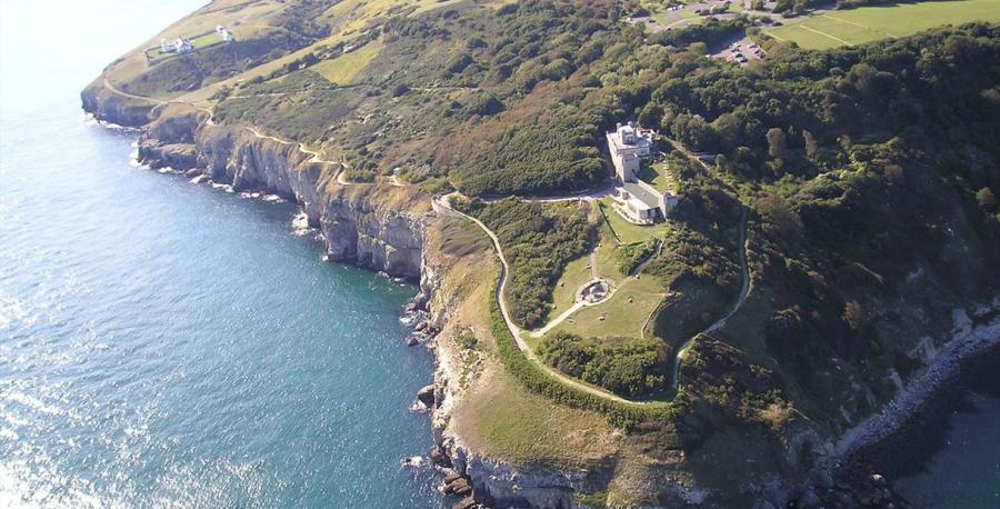

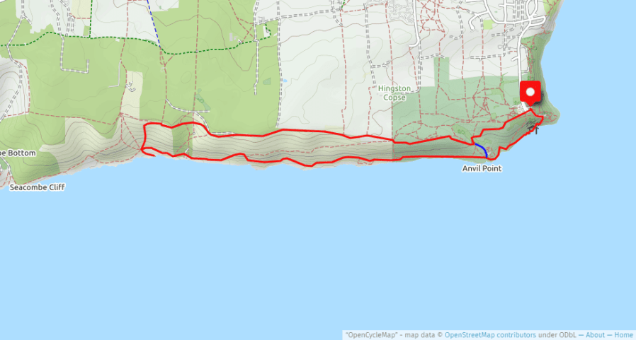
Follow the brown tourist signs through Swanage and up the hill to the town’s southernmost promontory of Durlston Head. This circular walk starts from the car park (red marker) for Durlston Castle, the recently restored Victorian folly which is now home to the Durlston Country Park and Nature Reserve visitor centre with interactive displays, exhibitions and cafe/restaurant. This circular walk can be shortened to a one hour loop (marked blue in above map) that includes the lighthouse and is a good option if you want to get out for an hour after being stuck in on a wet and windy day. Leaflets are also available from the visitors centre with alternative suggestions for themed based shorter walks around the area.
Commence the walk by heading from the car park in the direction of the castle and through the ‘Earth’s Timeline’, before passing below the castle and taking the wide right hand track down to the cliff top. Note the bollards on the side of the track which have the markings ‘City of London’, brought here as ballast in the returning stone ships during the quarrying period in this area. This section of the cliff top path has a low wall to provide a safe environment for bird and even dolphin watchers. Walking westwards you pass the entrance to the old quarry known as Tilly Whim caves, which became a popular tourist attraction in Victorian times when the railway opened up the area to tourists. At the end of the walled section the footpath opens up and descends into a dip before rising again in front of the Anvil Point Lighthouse, automated in 1991 and now operated from Trinity House in Harwich, and where more evidence of quarrying can be seen looking back under the cliff. [For the shorter loop back to the car park just keep to the lighthouse service road that heads up the valley].
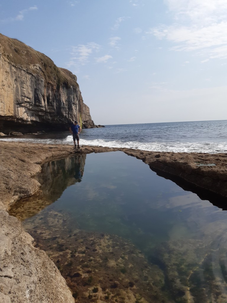
After leaving the lighthouse the cliff top path heads in a due westerly direction with the limestone cliffs of St. Aldhelm’s Head visible in the distance. Just before the lighthouse you will have passed the first of the Mile Indicator Posts used by ships to calibrate their speed over a measured mile, the second set appearing a nautical mile down the coast. Close to the cliff edge look out for some metal posts banged into the ground as this area is popular with rock climbers. This section of the cliff was also used by the US Rangers in 1944 as they practiced for the D-Day landings on Utah Beach. The approach to Dancing Ledge can be identified by the row of stiles that lead down to the ledge, popular with climbers, walkers taking a rest and even swimmers in the rock- blasted pool created for the local school children.
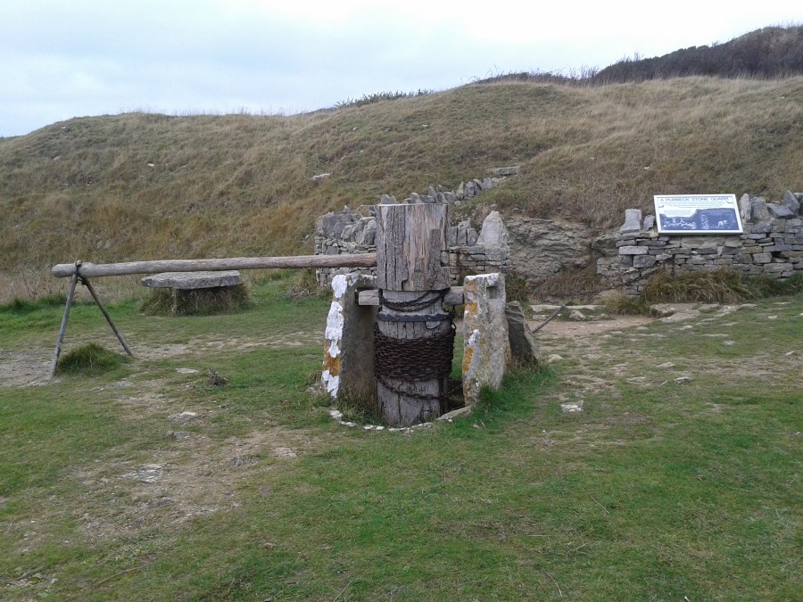
From Dancing Ledge head inland and up the slope until you reach the stone wall at the top with the route to Langton Matravers via Spyway Barn ahead. Keep to the seaward side of the wall and start heading eastwards along the visible track, dropping down into a dip then up the other side keeping right but without losing too much height. On the top grassy field you will see a gate to the right and from here the footpath continues east along the seaward side of the stone walls before opening up on an uneven ridge with great views east to the Isle of Wight. The route finally drops to meet the service road to the Anvil Point Lighthouse where you turn left and follow the road past an old quarry with a donkey powered capstan back to the car.
